When designing offshore measurement campaigns, the flexibility of remote sensing devices means the question on the mind of investors and developers should be “what do I want to measure?” rather than “what can I measure?”
Peter Clive / Senior Scientist / SgurrEnergy
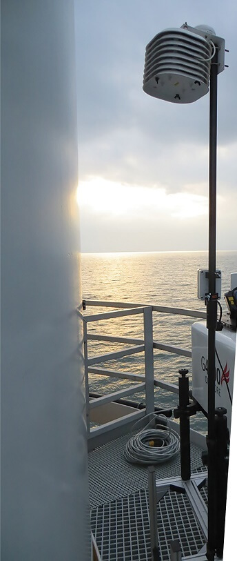
The lidar unit is mounted on the transition-piece walkway of an offshore wind turbine in the North Sea. The lidar provides a larger and clearer look at wind conditions than would be possible with anemometers alone.
Both wind-energy applications of remote sensing and onshore wind energy have an unrivalled pedigree in North America. For example, the construction of many pioneering projects took place in North America and the early adoption of remote sensing technologies such as SODAR have contributed to the datasets necessary to make these projects a success. Now, as the industry dips its toe in the water with the construction of the first North American offshore wind farm at Block Island, we have an excellent opportunity to review how remote sensing has helped deliver wind power in places where offshore projects are more established.
Offshore wind energy has flourished in European waters since the 1991 construction of the first offshore wind farm, 4.95 MW at Vindeby in Denmark. Over 11 GW of capacity is operating (representing more than half global offshore capacity), and in 2016, more than 21 GW has been consented and over €14 billion worth of projects have reached financial close. Remote sensing has played a crucial role in delivering this success, and it is reasonable to expect it to play an important one as developers roll out offshore wind in North American waters.
To achieve a return on the investment, the benefit that accrues from the acquisition of data must exceed the cost incurred acquiring it. One great advantage of remote sensing offshore is the massive reduction in the cost of data. For example, a power-curve test undertaken using scanning lidar installed on the transition piece of the test turbine can cost less than one percent of the cost of the equivalent test that using an offshore meteorological (met) tower.
But it is crucial not to overlook another advantage: the benefits increase as well. Remote sensing tools such as scanning lidar can give access to information that would otherwise be unavailable, letting us find out much more about the wind. To unlock the full value of lidar, it is important to see beyond using it as a met tower replacement. Lidar’s capabilities mean that measurement campaigns can go far beyond those of traditional offshore met masts, so why not exploit the vast array of measurement possibilities they offer?
Successfully developing and operating offshore wind-power projects call for detailed information and characterization of wind conditions. The wind cannot be controlled, but it can be measured. Established procedures rely on the limited capabilities of instruments that were available at the time the procedures were written. For example, cup anemometry mounted on met towers features heavily in standards and guidelines. However, in recent years remote sensing methods such as lidar have given us new techniques and methods of characterizing wind conditions offshore. Nacelle-mounted lidar, transition-piece mounted lidar, and other techniques on offshore projects across Europe have proven to be reliable sources of accurate and useful measurement data. This has provided an unprecedented understanding of the wind.
This more detailed understanding has led to more authentic approaches to uncertainty, and identification and quantification of what were previously ’unknown unknowns.’ This helps establish greater confidence in predictions, more effective project planning, and more suitable financial arrangements.
Expecting the unexpected
The wide-ranging capabilities of lidar mean we can better understand wind conditions. It is now possible to develop tailored methods to employ lidar capabilities more effectively, and mitigate hazards of adverse wind conditions. Lidar techniques give access to data that is otherwise unavailable. As a consequence, we have discovered that real-world conditions are much more complex than anticipated. We can now observe adverse conditions pre-construction instead of after a project has been built with limited opportunities for remediation. After all, prevention is better than cure.
For example, complex wind-shear phenomena, such as low-level jets, are revealed to have significant impact offshore. Variations in atmospheric stability over the course of a day can create conditions in which a layer of high wind speed develops. This can adversely impact wind turbine mechanical fatigue loads, such as bending moments at the blade root and gearbox torque variance, influencing component lifetime in a way that should be addressed in strategies for inspection, repair, operations and maintenance.
This understanding came as an unanticipated result of offshore lidar research. One such measurement campaign, using three scanning Galion G4000 lidars, was undertaken by Wood Group business SgurrEnergy and AREVA Wind at the Alpha Ventus Offshore Wind Farm in 2013. These were installed on the nacelle and transition piece of an offshore wind turbine in the German North Sea to undertake a wide variety of investigations.
One surprise discovery: wind-turbine compression zones were observed to extend further upwind than expected. This is the region in front of the turbine in which wind conditions are influenced by the presence of the turbine. When conducting turbine power-performance assessment, the incident wind resource is compared to the power production to see if the relationship conforms to expectations. If the resulting power curve is used with the results of a pre-construction wind-resource assessment to predict annual energy production, it is crucial that wind measurements are not influenced by the presence of the turbine. If so, they will impact power-curve tests and production estimates. This was another result highlighted only by the use of lidar offshore during the campaign at Alpha Ventus.
Choosing the right tool for the job
The versatility of lidar lets us choose the right tool for the job when it comes to measuring and understanding offshore wind conditions. Lidars don’t represent just one measurement method. A wide variety of techniques are available and the most appropriate one can answer a specific project-development question.
This flexibility is driving development of new guidance on the use of lidars by the International Energy Agency (IEA) Wind Energy Task 32. A “use case” approach has been adopted in which the lidar application is described with reference to the data requirements, the measurement method used to fulfil these requirements, and the situation in which the measurements are made. This is because different methods are suitable for different requirements, and a particular method may entail different levels of accuracy under different circumstances.
There are three key benefits to this approach:
• It provides a basis for consistent and comprehensive documentation of complex measurements to ensure repeatability and investor confidence in the results
• It clarifies the procedure for instrument calibration, whereby the verified performance of an instrument with respect to accuracy relates to a specific method employed under well-defined circumstances satisfying meaningful acceptance criteria to demonstrate fitness for purpose, and
• It places emphasis on the project-driven data requirements instead of using instrument capabilities for choosing measurements. Previously, constraint-driven approaches to measurement campaigns were adopted because of limitations to met towers. Remote sensing, and lidar in particular, has opened new opportunities that offer an outcome-driven approach to measurement.
Examples of new measurement opportunities include the installation of scanning lidar on a wind-turbine nacelle. This allows direct measurement of wind-turbine wakes behind the wind turbine and an evaluation of their impact. The measurements are compared to computational models, which can then be refined in the light of new evidence. This helps reduce uncertainties in energy yield estimates because wake modeling is one of the principal contributions to uncertainty.
In the absence of a met tower, the same device installed on the transition piece of a wind turbine makes possible the most IEC-compliant method of testing power performance. The location of the device on the transition piece fulfils the requirement in the 2nd edition of the IEC power-curve test standard for ground-based methods. The use of arc scan geometries ensures that lidar-probe volumes are also located in accordance with the requirements of the standard. This method has been used since 2013 to deliver reliable offshore turbine power-performance assessment testing at less than one percent of the cost associated methods based on met towers.
If there is no convenient location to install a device during the pre-construction resource assessment, an offshore floating lidar can be deployed in the absence of any other measurement opportunity, delivering essential valuable data. Recent studies indicate that even when installing a met tower offshore, it is more cost-effective to include a lidar on the platform because the improved financial arrangements achieved by the reduction in uncertainty can pay back the cost of the lidar several times over.
Multiple synchronized lidars can be used to achieve unambiguous, high-frequency measurements of wind velocity vectors throughout an entire offshore wind-farm array. Fast lidar measurements can also combine with computational flow models to enhance the level of detail and accuracy to describe wind conditions.
The flexibility of remote sensing devices means the question on investors’ and developers’ minds should be “what do I want to measure” rather than “what can I measure” when designing offshore measurement campaigns.
Transforming the way we do wind
Lidar techniques can obtain richer datasets acquired at lower costs compared with more established measurements. Sometimes they are required to fulfil the roles of these more limited instruments, such as met towers, to maintain continuity with established wind-energy assessment procedures. However, using lidars to emulate the more limited capabilities of met towers restricts their use unnecessarily. Based on lessons that the industry has learned so far, procedures must be updated to make the most of the measurement opportunities that lidar makes available.
Lidars should be installed for routine monitoring and validation of assumptions, rather than occasional compliance tests and resource assessments. Lidar is changing the way that the wind industry understands the wind, creating new ways to do business, and will continue to do so as the industry and the technology evolves.
Lidar measurements match the sophistication of computational model predictions, providing an invaluable test of their predictions and supporting an unprecedented degree of scientific rigour in wind energy assessment.
It is entirely possible that in the not-too-distant future, lidars will be employed in almost identical roles, pre and post-construction. The measurements will be compared to computational fluid dynamics, aero-elastic, and finite-element models from the pre-construction phase. They will then compare the predictions of those models to real wind-turbine performance and condition monitoring post-construction.
The benefit of experience
The onshore and offshore wind markets are ever-developing, giving North America a unique advantage in its position, entering the offshore market at a more reserved pace than other regions. With the benefit of extensive years of experience in onshore wind and wind measurement, combined with experience and lessons learned from the European offshore experience, the path is clear to use these lessons to develop the offshore wind industry in North America. Doing so eliminates some of the historical challenges faced by early adopters.
Moving towards gen 3 lidar
The first generation of lidar merely emulated met masts, requiring analysts to extrapolate to locations where measurement apparatus had not been installed, the same way one does with met masts.
The second generation introduced long range scanning to assess conditions throughout the volume of interest without requiring redeployment of apparatus or extrapolation from the instrument’s location. However, information about the wind remained incomplete – the device acquired line-of-sight values relative to its location, rather than absolute values – and so wind conditions were still inferred on the basis of a set of assumptions.
The emerging third generation will combine the time resolution of 1st generation devices and the space resolution of 2nd generation devices by allowing direct measurement where currently we rely on inference. The current state-of-the-art can be described as perhaps 2.5th generation, with trade-offs still required between time-and-space resolution with synchronized convergent beam systems. But progress is being made through, for example, the integration of rapid-flow modeling into the data stream.
Filed Under: Offshore wind


