Remote wind sensing is winning broader acceptance as wind farm developers use it to measure wind characteristics such as in-flow angle and turbulence. Investors are also putting confidence in remote sensing data. This message emerged from the annual Triton User Group sponsored by wind technology company and sodar manufacturer Second Wind.
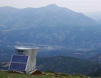
More than half of the users at one conference session said they are using sodar, such as this unit from Second Wind,on topographically complex sites and finding that the results correlate well with conventional tower-mounted instruments.
Independent engineers, consultants, and Second Wind Triton Sonic Wind Profiler customers envisioned a broader role for remote sensing (sodar) in their comments at the Triton User Group and workshop sessions held prior to the American Wind Energy Association’s annual conference. Users agree that remote sensing is a logical option as the wind industry searches for ways to reduce the uncertainty of evaluating and financing wind-power projects.
Second Wind’s Triton, an advanced remote sensing system, uses sodar (sound detection and ranging) to measure wind speed and direction. The company says measuring wind speeds at the turbine hub height and higher lets the units reduce uncertainty in annual energy production (AEP) forecasts. Easy to install (two men and a pickup) and with autonomous operation, these sodar unit are used throughout the wind industry, alone or with met towers, to streamline wind-farm development and to improve their operations. The panel included representatives of AWS Truepower, Chinook Wind, DNV Renewables, and GL Garrad Hassan.
A concern echoed by multiple panelists is that the portability of the remote sensors might encourage wind prospectors to shorten measurement campaigns. “We cannot complete a wind-resource assessment in a week!” said one panelist. His message was reinforced by another assertion that “Short-term measurement campaigns won’t reduce uncertainty but can lead to incorrect conclusions.”
Evaluating complex terrain was a recurring subject. More than half of the users at one session said they are using sodar on topographically complex sites and finding that the results correlate well with conventional tower-mounted instruments.
Throughout the conference, discussions focused on the importance of reducing uncertainty in wind resource assessments, and the increasing role that remote sensing systems play in reducing uncertainty. During a panel discussion on the future of resource assessment, Gisela Kroess, Managing Director, Project & Commodity Finance, UniCredit Bank AG, said the main source of the widely reported 10% underperformance of North American wind farms in recent years is due to overestimating wind speeds, a consequence of using flawed methods of measurement and extrapolation.
Second Wind
www.secondwind.com
Filed Under: News, Projects

