
Triton’s rugged design lets it operate in remote locations for extended periods. It can be installed by one technician and a vehicle.
The wind industry’s need for wind measurement has grown beyond the 60-m reach of standard meteorological (“met”) masts. To reduce uncertainty for wind projects that can cost anywhere from $100 million to $1 billion, the industry needs data from the entire rotor sweep that can’t be gleaned from 60, 80, or even 100-m met masts.
A 60-m met mast outfitted with sensors measures only about a quarter of the rotor sweep of a typical commercial turbine mounted on an 80-m tower. Taller masts are obtainable, but permitting and aircraft obstruction regulations make them challenging to site. And even where an 80-m mast is feasible, it only monitors the lower half of the wind powering the turbine. Is there a solution to met mast shortcomings?
Remote sensing is a credible alternative to mast-based measurements. Remote sensors are ground-based, and use sound or light to measure wind speed and direction at various heights. They can reveal the extent of wind shear events and wake effects. Developers prospecting new sites can use remote-sensing equipment to quickly identify the most promising turbine locations while eliminating marginal locations. With that intelligence, they can use fewer met masts and site them more effectively.
Beyond their height limitations, masts are firmly anchored to their location. If they’re not set up in the right area to measure the best wind on the site, it’s a cumbersome process to move them. Remote sensors, on the other hand, can be relocated in just a few hours. That makes them increasingly used for rapid wind prospecting, detailed wind resource assessments, and operations and maintenance studies.
Remote sensing
The “remote” in remote sensing refers to the separation between the devices and what they measure. Remote wind sensors operate on similar principles, whether radar, sodar, or lidar. They all emit signals of one form or another in a beam pattern. The emitted signals encounter variations in the air, reflecting back to the sensing equipment. Frequency changes from the original signals are interpreted as Doppler shifts, indicating that the sensed winds are moving towards or away from the instrument. Processing the Doppler shifts, elapsed times, and geometries of the emissions and reflections yields a profile of wind conditions.

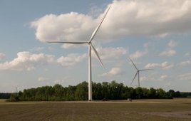
The Triton sodar wind-measuring unit runs on 7W, from a battery that recharges from the solar panels. Sucessful Triton campaigns have been conducted in varied topography.
Remote sensors used in the wind industry are based on either sodar (SOund Detection And Ranging) or lidar (LIght Detection And Ranging) technology. Radar isn’t used in wind energy applications because it can’t resolve wind speeds within a few hundred meters of the ground.
Sodar is a form of sonar, like that used for echolocation by dolphins and bats. Sodar sends audible acoustic pulses into the air, which reflect off encountered temperature differences. Microphones detect the resulting “back-scatter.” Calculating the time it takes for the sounds to travel back to the microphones yields the heights where the reflections occurred. Measuring the frequency change from the emitted pulse allows calculating wind speed towards or away from the instrument. Sending acoustic pulses in three or more different directions allows translating steeply angled wind speed measurements into horizontal wind speeds and directions over the measurement range.
Second Wind’s Triton is one example of a next generation sodar system. The Triton is built around a 36-element array of piezoelectric trans-ducers, which operate as either highly efficient speakers or microphones. In speaker mode, the array emits sonic “chirps” that reflect off an internal sound mirror and into the atmosphere. Switching to microphone mode, the arrays record echoes from the sound scattering.
The array is called “phased” because individual transducers are operated in acoustic phase with each other. Phased arrays are used in radio astronomy and other precise imaging applications, because they substitute inexpensive and efficient small transducers for more costly, larger equivalent devices. The transducers can create a better-directed beam and listening cone than a single speaker-microphone, thanks to the physics of interference patterns. Only one array is needed for three different beam directions. Triton achieves this by introducing time delays between rows of transducers, there being three-row orientations 120° apart in the hexagonal array pattern.
The U.S. Department of Energy’s National Renewable Energy Lab reports that sodar delivers accuracy comparable to tower-mounted meteorological instruments. The lab recently tested a Triton and found its wind speed and direction data correlated well to instruments mounted on meteorological towers.
“We see Triton as a valid stand-alone system for wind measurement studies,” says NREL Principal Scientist Dennis Elliott. “In addition, the sodar unit was reliable, with an uptime of more than 98%.”
The Energy Research Center / Netherlands came to a similar conclusion after comparing Triton data to data from a 100-m meteorological tower mounted with four anemometers and wind vanes at different heights. While maintaining 98.85% operational availability, the sodar unit provided data on wind speed, direction, shear, and turbulence intensity that qualified it as “a stand-alone system for wind resource assessments, especially given the industry’s tendency toward higher hub heights,” states the report.
Lidar, like sodar, measures wind speeds by processing the Doppler shifts of its emitted beams. A lidar either pulses or continuously fires a solid-state infrared laser while motorized mirrors or optical waveguides maneuver the beams. These strike particles in the air, “aerosols,” which reflect back to the source instrumentation where photosensors detected them.
In the case of lidar, the Doppler shift takes the form of a slight color change in the radiated laser light. The shift is generally not directly measurable due to light’s ultra-high frequency. Measurements are using various electronic and optical modulation and detection techniques.
Like sodar and sonar, lidar technology has been in use for years in applications other than wind power. Meteorological lidar has been used successfully to measure narrow regions of air, sometimes to distances as great as 15 km. Such systems have been built with color-tunable lasers, high-power requirements, and great expense, typically upwards of $1 million.
Lidar systems now at work in wind-energy applications use lasers and optical detectors developed for fiber-optic communications, so they are not tunable for atmospheric applications. They have limited power – typically in the hundreds of watts instead of kilowatts – giving them a range comparable to sodar: hundreds of meters instead of kilometers.
Sodar and lidar each have advantages and disadvantages. Lidar’s strong suit is response time. Light speed permits many more measurements than can be made in the round-trip time of sound waves traveling a few hundred meters. Lidar can make second-by-second wind-speed measurements, which are useful for wind turbine controls. For resource assessments, however, the high response speed possible with lidar has no particular advantage.
Sodar’s technical advantages include an inherently lower cost and power of basic transducers. These are not academic considerations. There are several sodar systems available from $50,000 to $75,000, while the lowest cost complete lidar systems carry price tags of $150,000 to $250,000. The lowest power sodar, Triton, consumes 7W on average. The lowest power lidar system is reported to be 45W. For remote applications this is a substantial difference.

Sixty-meter met towers sample only about 20% of the wind that blows through a turbine rotor. Remote sensing can reach up to 200m providing a more accurate picture of what the wind is doing.
For the wind industry, sodar is inherently better at making precise frequency shift measurements than the lidar technology used in wind applications. Audio frequency measurements of hundreds of parts per million is commonplace. It is difficult to make, within a percent, accurate measurements of fiber-optic laser emissions that have been Doppler shifted by wind speeds of just a few meters per second.
Both sodar and lidar have characteristics that can limit the range and reliability of their data. For example, sodar is susceptible to ambient noise in the range of its operation, especially at lower frequencies. Dry, thermally homogenous air affects sodar’s performance and it can’t compete with a hard rain. Lidar cannot work through a dense fog and its performance drops in clean air, including after rainfall where the aerosols have been washed away. Lidar can also have issues with sunlight and cloud cover.
However, anemometers and wind vanes are also prone to malfunctions and failure from rain, freezing, and dust. They perform nonlinearly in the presence of non-horizontal flow, and can’t measure inflow angles. Mast-mounted sensors are vulnerable to lightning strikes and other environmental hazards – much less of an issue with ground-mounted remote sensors. The reliability of remote sensing systems’ can rival that of the best conventional mast-based systems. And the reliability of 100 m-plus lidar or sodar is greater than extrapolations made from measurements from a 60-m mast.
Reducing uncertainty
The current political and social climate forecasts big growth for wind power. That growth will not occur, however, unless developers can convince investors that wind power is a reliable, profitable power source. There is inherent uncertainty in banking on the wind. Investors don’t like uncertainty, so it’s incumbent on developers to reduce it.
Meteorological towers don’t yield enough data. They don’t reach high enough to measure a modern turbine rotor’s full sweep, which forces developers to rely on extrapolations. There’s no reason to do that when remote sensing can provide the missing data.
Furthermore, the wind-power industry would benefit from a new equation between fixed and remote sensing. The current standard is to erect three to five masts for every remote sensor used on a site. That ratio should be reversed: three to five remote sensors for every mast. Remote sensing equipment should be the primary data gatherer. They’re just as accurate as mast-mounted sensors, gather more data, and are more cost effective, and versatile. Mast-mounted sensors’ proper role right now is providing reliable data baselines for correlating remote units.
Combining remote and fixed sensing in these roles adds up to more comprehensive wind data sets that reduce the uncertainty inherent in wind farm development. Combined, they offer wind-farm developers persuasive facts to attract investors, while offering investors an assurance of a return on their investment. WPE
-Susan Giordano/Second Wind Inc, Somerville, Mass./www.secondwind.com
Filed Under: Uncategorized


“Sound intelligence in the search for wind power” in reality
got me personally simply addicted on your blog! I personallywill
probably be back significantly more regularly. Thank you -Terence
It is very nice to read all that posts we are really into something big in trying to cope up in trying to maximize our nature to develop cheap and environmentally friendly energy. Hope this would bring the change in the environment and hope that you can also share this instrument to the less fortunate countries around the globe.
Thanks for your good words and thoughts.
–Paul Dvorak