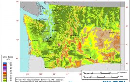
The Department of Energy’s Wind Program and the National Renewable Energy Laboratory (NREL) has published a wind resource map for the state of Washington. The resource map shows the predicted mean annual wind speeds at 80-m height. Presented at a spatial resolution of about 2 km (interpolated to a finer scale for display). Areas with…
Where the winds are – in Kansas
The Department of Energy’s Wind Program and the National Renewable Energy Laboratory (NREL) has published a wind resource map for the state of Kansas showing a predicted mean annual wind speeds at 80-m up. It’s presented with a spatial resolution of about 2 km (interpolated to a finer scale for display). Areas with annual average…