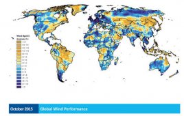
AWS Truepower’s monthly wind performance maps are released shortly after the end of each month. This new service offers an enhanced look at the company’s Wind Trends, which provide a quarterly snapshot of wind performance. The new monthly performance maps show deviations in the wind resource from average conditions in every region of the world…
Assessing cumulative visual impacts for wind projects
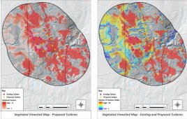
By John W. Guariglia RLA Associate Principal | Saratoga Associates The potential effect utility-scale wind energy projects have on the aesthetic quality of regional landscapes is a common concern for regulators and stakeholders. Failure to address this concern early in the public review process can lead to misinterpretation, diminished public confidence, and delays in project…
New wind resource maps reach higher heights
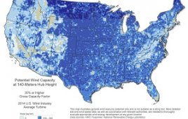
The National Renewable Energy Laboratory (NREL) and AWS Truepower recently released maps that illustrate the potential for wind-energy development using more advanced wind turbine technologies. Wind resource maps are one tool wind industry professionals use in the early stages of wind project planning to understand the potential for wind development in a region. Because stronger…
Maps show areas where sea breezes most useful
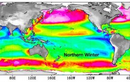
Efforts to harness the energy potential of ocean winds could soon gain a new guide: global satellite maps from NASA. Scientists have been generating maps using nearly a decade of data from NASA’s QuikScat satellite that reveal the best ocean areas where winds could produce energy. Potential uses for the maps include planning offshore wind…