By Elvira Aliverdieva, product specialist; and Mathias Regnier, WindCube product manager, Leosphere, a Vaisala Company
All around the globe, offshore wind energy is gaining significant momentum. In 2020 alone, the world added more than 6 GW of new capacity via offshore installations. As global interest in offshore wind energy continues to grow in both near-shore environments and in deeper waters further from coastlines, the project pipeline is expected to contribute an additional 238 GW of offshore wind energy by the end of 2030.
Europe, the world’s largest regional offshore wind market, is expected to maintain steady growth in the near future. China anticipates continued domination of the Asian market challenged by other regions such as Japan, South Korea and Taiwan. Under the current administration, the United States has state its goal to deploy 30 GW of offshore wind by 2030. As the offshore wind market grows and becomes increasingly mature, large financiers and some of the most well-known oil and gas companies are investing billions of dollars into the business of offshore wind.
While offshore wind farms promise excellent wind availability and energy capture, do not disrupt communities and are not as vulnerable to many common performance degradations that come with complex terrain and onshore wind farm crowding, they also bring a new set of challenges.
Everything is bigger offshore
With offshore wind, bigger is better. Offshore wind farms cover more expansive areas, are located at greater distances from the shore and utilize larger turbines that reach taller heights — all of which contribute to increased power generation. In fact, turbine manufacturer Siemens Gamesa in May announced the launch of what will be the world’s largest offshore wind turbine — a behemoth with a 222-m rotor and 14-MW capacity.
However, accurately assessing wind characteristics for taller turbines and larger areas as well as obtaining precise wind data at long ranges from the shoreline is increasingly challenging. This is especially true when considering the traditional equipment for wind measurement — meteorological masts — is often either impossible or prohibitively expensive to deploy and maintain offshore. This highlights the need for a solution that easily measures up to the full height of today’s turbines without mathematical extrapolation and can be moved around the site to conduct additional measurements or moved to support another campaign.
Consequently, uncertainty of the energy yield assessment is another significant issue. Since wind farms and the capacity of turbines are much bigger offshore, optimizing the evaluation of the wind resource can result in a positive economic impact. This is why an accurate performance and production forecast is critical to the bankability of a project during the development stage, and wind monitoring and power performance testing throughout the project’s operations require the most precise measurements possible to reduce uncertainty.
Enter lidar technology. Lidar is able to measure, with precision, the full wind regime. This includes characteristics of the wind flow and data such as wind speed, wind direction and turbulence up to 300+ m in height using vertical profilers, 700 m in front of turbines with nacelle-mounted lidar and 10+ km from the shore or from a platform with scanning lidar technology — all in real time.
One size does not fit all
Lidar is the most comprehensive offshore-ready measurement technology in the world. There is a lidar solution to support every phase of an offshore project, from wind resource assessment and contractual and operational power curve testing to permanent wind monitoring, research and development, turbine control and prototype testing.
Each wind farm is unique and presents its own challenges. Accordingly, flexibility is key with developers requiring a range of solutions to accommodate each stage of a project. Fortunately, lidar technology makes it possible to measure accurately the full wind profile of even the largest offshore turbines. It also delivers significant flexibility as it is simpler and cheaper to deploy and repurpose throughout the lifecycle of an offshore project.
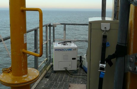
While it is the make-or-break point for any wind farm project, wind resource assessment is particularly difficult in offshore development. Fortunately, vertical profiling lidar can be deployed nearly anywhere as part of the floating lidar system (FLS) to ensure direct on-site wind resource assessment for greenfield projects while reducing uncertainty. Alternatively, vertical profilers can be mounted on existing offshore platforms, ships or lighthouses depending on project specifications. Scanning lidars can also be placed on existing offshore platforms or onshore at the coastline to provide the spatial resolution to analyze bigger areas, thereby decreasing uncertainty and improving project bankability.
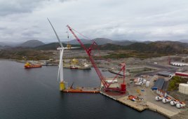
Fixed vertical-profiling lidars are also increasingly being used during craning and mounting operations because they help ensure safety and accurate weather forecasting, which is necessary for turbine placement and installation. Additionally, scanning lidar enables users in the construction or commissioning phases to conduct power performance testing of multiple turbines with just one lidar unit.
Advanced scanning lidar technology allows for full 3D spatial mapping of the wind field over the water and at long range, and it is much easier and more cost-effective to operate and maintain from the shore. Plus, by leveraging a dual-scanning lidar solution, developers can increase the coverage, accuracy and efficiency of offshore measurement campaigns. A single-scanning lidar provides rich data from one strategically chosen vantage point. However, dual-scanning lidar provides an even more comprehensive picture of the wind resource profile by observing an offshore location from multiple positions. With dual-scanning lidar, project owners realize a richer understanding of nearshore wind resources, with reduced uncertainty and more bankable, reliable data.
Best of all, these technologies can be mixed and matched depending on the situation. For example, on a typical greenfield project, a buoy-mounted vertical profiler lidar can be placed at the center of a proposed wind farm to reduce vertical uncertainty, while one or several scanning lidar units provide 3D wind awareness from the shore or a platform.
Operators are also tasked with implementing turbine control practices to improve energy capture and increase efficiency. However, this requires extreme precision and a significant amount of data with which to work. Nacelle-mounted lidar fulfills these requirements and is ideally positioned for lidar-assisted control (LAC), reducing loads and costs. When used for permanent wind monitoring, fixed vertical-profiling and nacelle-mounted lidars can monitor performance and losses when a turbine is stopped or the farm is off the grid.
Contractual power curve verification is one of the most important tasks along the road to operation, and nacelle-mounted lidars are proven to dramatically reduce operational costs while increasing efficiency, making them widely accepted for contractual power performance testing (PPT). Used to verify performance or validate repairs and upgrades, operational PPT is crucial as well. Nacelle-mounted lidar operating on a pulsed lidar principle has the capability to maintain constant accuracy over the entire measurement range while offering the highest accuracy, data availability and sample rates regardless of weather conditions. This makes it well suited for troubleshooting and identifying underperformance. Plus, nacelle-mounted lidar measures horizontal wind hundreds of meters in front of turbines to simplify IEC-compliant PPT and ensure even the largest offshore turbines are performing at maximum capacity.
In addition, some out-of-the-box software platforms simplify and streamline the delivery of power performance data. By combining both lidar data and supervisory control and data acquisition (SCADA) turbine performance intelligence, data analytics software tools rapidly deliver quick, easy and transparent IEC-compliant PPT calculations, empowering customers with the ability to focus on the most essential performance analysis work.
The importance of operational continuity
Offshore projects operate in harsh, salted environments far from maintenance resources, so ensuring operational continuity is crucial to a project’s success because accessing an offshore wind farm is complex, unpredictable and costly. A significant component of operational continuity is trusting the solution has been validated and certified to reliably work.
When lidars are validated and certified by the world’s leading independent certifying bodies and research institutes (including DNV, DTU Wind Energy, UL, Deutsche WindGuard, NREL and AIST), developers and operators know the equipment meets the latest and most rigorous international verification standards (including ISO9001) and is compliant to the latest IEC standards. Validation and certification give more certainty to the results of the campaign, and lidar solutions are therefore evolving from a nice-to-have option to being critical to ensuring operational continuity.
Whether developing or operating a wind project, lidar sensors are trusted by decision-makers to understand what the wind is actually doing at a given site. Lidar is meeting many previously unmet needs for offshore developers and operators and can also provide critical data for studying and implementing wind farm extensions. With the right lidar tools and a modern approach, offshore wind farms are technically feasible, as well as efficient and financially sound. While wind farms might be an expensive, long-term investment, the lidar ease of use, time savings and operational efficiencies unlock a more certain energy generation system.
 Elvira Aliverdieva is a product and marketing specialist for Leosphere, a Vaisala Company. She participates in the evolution of the company’s onshore and offshore wind product strategy, with a primary focus on the booming offshore market.
 Mathias Regnier is the Product Manager for the WindCube Offshore lidar at Leosphere, a Vaisala Company. As such, he continually evaluates customer needs in order to develop lidar product strategies and solutions for the booming offshore wind market.
Filed Under: Featured



Very interesting reading.