By Donavon Graves, Director of Business Development and Strategic Planning, Skyward – a Verizon company
Drone inspections play a vital role in preventive maintenance of vertical structures, ships, worksites and horizontal infrastructure like railroad tracks and power lines. Therefore, connected drones are the next phase of this technology. In the near future, the main mode of operations for unmanned aerial vehicles (UAVs) will be autonomous flights, beyond sight line of any pilot. Automation plus emerging 5G cellular networks can make the work of inspecting wind turbines far faster and also yield better insights at much less cost.
Improved maintenance could lead to more reliable wind power generation and improved ROI by extending the life of turbine blades. Let’s look at how this is unfolding with the latest advances in uncrewed aerial systems (UAS).
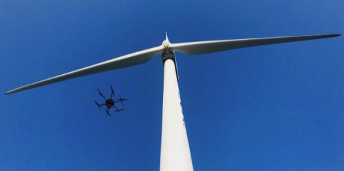 The present: Current wind turbine inspections with drones
Today, a field team heads to a wind farm with a drone equipped with high-resolution photography, LiDAR (light detection and ranging) and thermal detection instruments. During the inspection flight, the drone captures high-resolution images that can measure erosion on blade edges. The infrared camera and LiDAR sensor look for hidden damage inside the equipment, seeing up to 15-cm deep. The data collected is most likely saved onto a secure digital (SD) card, uploaded to a laptop and emailed back to the office for analysis. This entire inspection takes about 45 minutes.
Back at headquarters, the images are analyzed by an AI program and compared with previous inspection findings. A technician evaluates any changes that could cause concern, and servicing is scheduled for needed repairs, heading off expensive, bigger problems at a later date.
The future: Connected drones for inspections
Now let’s take it a step further. Imagine dozens of UAVs staged near a wind farm. They’ll be programmed to do routine inspections on a frequent schedule and also be at the ready for any unscheduled flights needed after weather events, helping to identify equipment damage.
These aerial robots will be equipped with computer vision to understand the surrounding aviation environment and detect other aircraft to avoid collisions. They’ll be registered with remote identification capabilities, allowing them to avoid conflicts with crewed aircraft and be tracked by authorities. They’ll fly autonomously in airspace governed by a universal traffic management system (UTM) for drones, similar to what the Federal Aviation Administration (FAA) runs for commercial aircraft.
The drones will be connected to the high speed, ultra-low latency 5G wireless network through small communication nodes placed right on structures in the field. AI software will guide the UAVs as they look for potential damage, guiding the drones to problem areas. Technicians could view the drone video in near real time.
While technicians onsite can view the drone video essentially in real time, the data being collected — terabytes of high-definition video, infrared sensor data, LiDAR measurements — could be livestreamed back to the office where more AI-powered software instantly evaluates it. Edge computing will allow much of this data to be processed without it having to travel between distant servers far away from the office, resulting in a quicker process and allowing dozens of towers to be inspected simultaneously.
When a problem is found, wind turbine service technicians will be instantly notified, along with the precise location of the equipment. As a result, units will be kept in better repair, reducing the time they’re offline and maximizing energy generation.
This is not the stuff of science fiction. Many pieces are already in place to deliver on this vision.
The role of 5G
Three attributes of next-generation wireless networks are especially relevant for connected drones: very low latency, energy efficiency and reliability.
- Very low latency: Latency is described as how fast a piece of data moves from one part of a network to another. When there’s a delay between the visuals and the audio of a movie you’re streaming, you’re experiencing latency. 5G will cut data transit speed to many times less than the blink of an eye — eventually less than a 10-millisecond end-to-end response time. This reduced latency will create a near real-time experience for drone and sensor operators in terms of sensor response, drone control and delivery of the media and data collected. Lower latency should allow remote UAV crews to fine-tune sensor movements and drone position to get the perfect angle for a shot or analysis without experiencing meaningful control lag.
- Energy efficiency: 5G is expected to have up to 90% lower energy requirements than 4G. With 5G, complex functions can take place within the network near the end user. Devices shouldn’t need as much processing capability and should consume less energy. This is an appealing benefit for any organization with a big stake in reducing carbon emissions, like the energy industry.
- Reliability: Drone aviation requires very high levels of reliability. New 5G networks are being built with a focus on reliability (among other attributes), which should provide the confidence necessary for drones to operate over the network.
Progress on a unified airspace system for drones
The commercial drone industry and the FAA are working toward a system of low-altitude traffic management to help keep the skies safe as this new era arrives. The vision is for an automated, unified traffic management system for flight approvals, coordination with FAA air traffic control and low-altitude airspace compliance. The system would integrate weather service and other data. Every drone in the air will be instantly identifiable and equipped with collision-avoidance technology.
Improving insights and analytics with connected drones
Connected drone technology will also be a big advance in maintaining energy, transportation, water and other infrastructure systems. It will enable faster visibility into areas affected by disasters. 5G technology is designed to enable devices that are traveling up to 310 mph, such as a drone, to stay connected to the network. UAVs already provide aerial views to repair people assessing damage after a wind event, flood or lightning storm. With 5G, massive stretches of power lines could be examined in minutes, with insights on conditions fed instantly to responders. Wind farm managers could see what’s going on with turbines even when ground conditions are still dangerous or impractical.
New 5G networks are being designed to allow up to 1 million devices per square kilometer to be connected wirelessly. Coupled with AI, devices operating on 5G wireless should be able to more quickly produce actionable information out of raw data. Drone-generated videos, LiDAR readings, photos and thermal data could be processed near the site of collection and transferred to decision makers in near real-time. In addition, wind power generators will get better analytics on supply and demand or system waste.
Added reliability and ROI for wind power
Total global wind power capacity is expected to grow 62% by 2024. With the cost of a new wind turbine blade running about $1 million, it is imperative to keep turbines functioning at peak capacity and maximize their lifespans.
UAS has already dramatically improved the pace, quality and frequency of wind turbine inspections. Autonomous, connected drones operating on a 5G network should present more possibilities. Intelligent video, remote diagnostics and near real-time analytics will help technicians see what may be on the brink of failing sooner. Managers will be better able to assess damage, prioritize repairs and predict maintenance. And as a result, the fleet of hundreds of thousands of turbines humanity relies on to deliver clean energy will become more efficient and reliable.
 Donavon Graves is director of business development and strategic planning at Skyward, a Verizon company. He works with companies to empower successful drone adoption and management, drawing from extensive expertise garnered through his work in transportation, logistics, utilities, construction and oil and gas.
Filed Under: Components, Drones, Featured, O&M, Safety, Services

With current quality of blades and erosion problem solved who would pay for this ? Flying BVLOS is much more complicated and the drone cost would like 5 double in price.
Drones are besides this due to GPS proxy 3% (2 degrees times the distance to blade) or more inaccurate meaning on 100 meter blades the finding on the blade can be any where in a 3 meter range and it moves every time an inspection is done.
Drones already help with inspections and I look forward to seeing how the next advancements in drone technology will help keep wind turbines functioning at maximum capacity in the future!