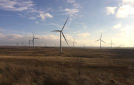
Kansas winds at 80m.
The Department of Energy’s Wind Program and the National Renewable Energy Laboratory (NREL) has published a wind resource map for the state of Kansas showing a predicted mean annual wind speeds at 80-m up. It’s presented with a spatial resolution of about 2 km (interpolated to a finer scale for display). Areas with annual average wind speeds of about 6.5 m/s and greater at 80-m height are generally considered to have suitable wind resource for wind development.
Also, says NREL, which supplied material for this article, a national dataset was produced estimating gross capacity factor (not adjusted for losses) at a spatial resolution of 200m and heights of 80 and 100m. Using AWS Truepower’s gross capacity factor data, NREL estimated the windy land area and wind energy potential in various capacity factor ranges for each state. The table (Excel 109 KB) lists the estimates of windy land area with a gross capacity of 30% and greater at 80-m height and the wind energy potential from development of the “available” windy land area after exclusions.
Installed capacity is the potential megawatts of rated capacity that could be installed on the available windy land area, and the “Annual Generation” is the estimated annual wind energy generation in gigawatt-hours that could be produced from the installed capacity. NREL reduced the wind potential estimates by excluding areas unavailable for developed such as wilderness areas, parks, urban areas, and water features (see Wind Resource Exclusion Table for more detail). Additional wind potential tables (Excel 197 KB) are included for various capacity factor ranges.
The accompanying plots of capacity factors show the wind resource potential above a given gross capacity factor at both 80 and 100-m heights for Kansas.

Estimates show potential MW of rated capacity that could be installed on land above a given gross capacity factor (without losses) at 80 and 100-m heights. Areas greater than 30% at 80m are generally considered to have a suitable wind resource for development with today’s turbines. AWS Truewind LLC developed the wind resource data for its windNavigator with a special resolution of 200m. NREL filtered the wind potential estimates to exclude areas such as parks and lakes.
These maps and wind potential estimates resulted from a collaborative project between the National Renewable Energy Laboratory and AWS Truepower of Albany, New York. This is the first comprehensive update of the wind energy potential by state since 1993. NREL has worked with AWS Truepower for almost a decade on updating wind resource maps for 36 states and producing validated maps for 50-meter height above ground. U.S. Department of Energy’s Wind Powering America project supported the mapping efforts.
NREL further suggests that the wind resource at a micro level can vary significantly so get a professional evaluation of your specific area of interest.
NREL
nrel.gov
Filed Under: Construction